Thứ Ba, 17 tháng 7, 2012

Rocky Mountain High - Taylor Park Reservoir


Our View!
Hi all, Dianne here.  Roger and I just spent four relaxing days at Lakeview Campground in the Gunnison National Forest.  We have a great view of Taylor Park Reservoir just down the hill.  It's a good thing we are just relaxing here, because at 9,400 feet elevation, we've both been short of breath just walking around the campground!  


Bandido Looking for Grasshoppers
It's a beautiful spot.  We've had sunny, 60 to 75-degree days and nights cool enough to run our furnace in the mornings to warm things up.  No mosquitos, either!  We have had afternoon showers most days this week, but they really haven't been a problem since we're just hanging out anyway.   We have the same beautiful view out our side windows as from the patio area.  No water or sewer hookups, but 50-amp electric and a clear sky for our satellite.


Roger had a good time setting up our spacious patio, complete with his hammock strategically placed under the Sunbrella for shade.


Charlie the cat even had some quality time outside.  This setup worked really well until one afternoon Roger heard strange noises and realized Charlie had managed to catch a mouse!  I guess you can take the cat out of the farm, but you can't take the farm out of the cat!  

We never tired of the view -- it was different every day, depending upon the cloud height, sun, fog, etc.  We got lots of reading done, plus crossword puzzles (Roger) and sudoku (me).  


An added bonus were the variety of mountain hummingbirds that frequented my feeder.  This rufous hummingbird practically became a pet while we were here.  I also saw a calliope hummingbird and a broad-tailed hummingbird.  I got good looks at them and added all three to my life list, but wasn't quick enough to get photos of the other two types.


We always keep a squirt gun handy to give Bandido a squirt if he starts to bark or "growl" at passing dogs outside the RV.  Last evening he started in with his low, rumbly growl and Roger went to the window and said, "Bandido, there's nothing out there  -- oh, wait a minute!  Yes, there is!"  


This pretty deer came right up into the campground and was grazing between the sites.  


He stayed around for quite awhile -- didn't seem the least bit afraid.  Bandido was so interested in watching him through the window that he forgot all about growling at him.


We wondered if we'd even make it here, because once we passed through the last small town on our way (Almont) there was serious road construction -- we're talking down to the dirt -- between Almont and Taylor Park Reservoir.  A 23-mile drive took us over an hour.  First there was no pavement, only dirt.  Then there was a flagger and a pilot car through a blasting zone.  


Here and there we passed through soft patches of dirt, and had to weave around construction equipment.
This went on for more than eight miles.


The motor home actually slid a bit in one soft section.  Other sections of the dirt road were very washboard-y.  It wouldn't have been fun in a pickup truck or Jeep, let alone in a 36-foot motorhome.  It was so bumpy that when we finally arrived and tried to put out our bedroom slide, we heard a strange noise and it wouldn't go out all the way.  Roger got up on the bed with a flashlight and saw that the wood trim strip from above the bed had been jiggled out of the wall and had fallen behind the slideout.  Luckily, we stopped it in time that it didn't break either the trim or the slideout, so a quick hammer project from Roger made it good as new.  


We both worried with the daily afternoon rain storms that this route back out would become a mud pit.  It was bad enough dry!  Roger spoke to another camper who suggested we take a local (dirt) road over Cottonwood Pass to get to our next destination, Chalk Lake.   Not wanting to drive the motorhome on a dirt road over the Continental Divide just on a stranger's suggestion, we did a trial run in the Matrix this afternoon to see if it was feasible.
Wow!  What scenery!  It would have been worth the drive even if we weren't checking it out.  I'm really glad we didn't miss it.


The road itself was dirt all the way to the summit, but it was graded and in much better shape than the construction zone.  


It was 13 miles from Taylor Park Reservoir to the summit.  The road was wide enough, a few pull-outs here and there if we need to let traffic pass, and not too many sharp curves.  


We switchbacked up the mountain and reached the timberline that we'd been viewing from our camp site for the past few days.


Soon we reached the Cottonwood Pass summit (12,126 feet) and parked to stretch our legs and give the "kids" a quick walk.


We were above the tree line at this point and took a short hike up a hill from the parking area.  We didn't go far, because the daily storm clouds were gathering and we wanted to make it back to the RV before the rain began.  The temperature up there was a cool 51 degrees.


I took a few photos from the summit:


Dirt Road Western Side
The road up the western side of the summit is dirt, but the road became paved at the top and is paved all the way down the eastern side.  We didn't go further than the summit, because we knew if we could make it up there on the dirt road that we'd have no difficulty going down on the paved road.


Paved Road Eastern Side
Roger had the Matrix in third gear going up, but we both agree that the motor home should do just fine in low gear.  There is very little traffic on the road, but what traffic we saw included several travel trailers and fifth wheels.  Roger even posed a question on rv.net Roads and Trips message board, and the consensus was that we could do it.  It will also shave about 60 miles from our trip today.


Just a FYI, for the next four days we'll be off the grid with no electricity and therefore no internet.  We'll check back in when we reach Colorado Springs next week.  If you post a comment on the blog, just know that it might be several days before we are able to see it, so it might not show up for a while.


The pet photo of the day is a shot I took through the passenger side mirror of Tequila enjoying the mountain air from the back seat as we drove to the summit. 

Chủ Nhật, 15 tháng 7, 2012

Budgeted stay near London Olympics Stadium


Hurry up! It’s time to secure your lodge near the Olympic park. If you want to travel in a budget then there is no time to waste. The price will goes higher with every single minute close to Olympic 2012 opening, but fortunately you can still have some time to save some pounds. Now its time to take a look on some lodges rates as there are several hotels near the Olympic park that can still fit in your budget including the one listed below


Holiday inn express London lime house


Budgted Hotel in london
This is a famous three star hotel for those who want to travel in a budget, located in the heart of London’s dockland. You can get a double/twin room just in £91 including breakfast and no cancellation charges. It’s an affordable choice just 2 miles away from Olympic park 2012. Holiday inn express London lime house is close to DLR station and there is only one stop between lime house and the bank tube station.

Amhurst Hotel

hotel in London
This is a peaceful hotel renovated with soothing texture offer most affordable accommodation in the residential area of north London. The bus routes are just 5 to 10 minutes away from Amhurst hotel. Olympic park 2012 is 5.9 km away from the hotel. You can enjoy above average facilities just in £35 per night which includes Wi-Fi and free parking. It’s an ideal budgeted option for small groups and couples.

Cottage 3L (live long laugh)

hotel in budget
Cottage 3L is a two star self classified hotel suitable for young friends, groups and couples who are looking for calm stay in London. The house is with seven bedrooms and fully equipped kitchen just in £89.95 per night. Cottage 3L is a brand new hotel 15 to 20 minutes away by bus from Olympic stadium. It’s quite near to shopping area of wood grange road and best choice in the budget for long stays.

These hotels do not embrace the complete list these are just few reasonable options. The most important is that if you want a trip in an allocated budget then it’s a time of reservations of lodges for summer Olympics so don’t delay any more to enjoy the summer Olympic in London according to your budget preferences.

Ouray Perimeter Trail


Roger here...  The photo above is of the Lower Cascade Falls just outside of Ouray, CO -- and Dianne, of course.

With just a couple of days left in civilization before we headed to forest service campgrounds in the boonies, we needed to plan carefully.  We wanted to do another hike.  We needed to buy groceries for eight days.  We needed to replenish our supply of dog treats.  

Dianne decided that she would go shopping on Wednesday to get it out of the way, allowing us to better enjoy the hike on Thursday.  I stayed with the dogs.  She spent the morning figuring out what kinds of food I could prepare on the grill, since we would not always have electricity.  After hours of shopping in Montrose, this is what she brought home:


It seems that we were running low on dark chocolate.  We have one or two pieces almost every night.  When Dianne passed the local Russell Stover outlet and saw that some items were 75% off,  Grandma Robison's frugal spirit pulled her into the parking lot.  She did also bring home groceries and dog treats.  (Dianne here:  In my defense, I got all of this dark chocolate for $9; it should last us a couple of months.  If I break each of the six bunnies into small pieces, I really did save a lot!!  I don't mind Santas and Easter Bunnies in July if I can save a buck!)

Thursday morning arrived.  We could not decide which hike to take.  Rather than going back to Black Canyon National Park, we decided to do the Ouray Perimeter Hike.   At the last minute we decided not to take the dogs.  This was going to be a 4.2 mile hike with some elevation.  Bandido is always great for the first half-hour, but then slows down and seeks soft places to rest.  We were also concerned that Tequila might see a lizard and pull Dianne off a ledge.  (We all know that Dianne would not let go of the leash).  As it turns out, it was a great decision.  Sorry, doggies.

We got somewhat of a late start, arriving at the Ouray Visitor Center at around 11:00 a.m.  The volunteer at the visitor center gave us a trail map and told us that the trail was well marked.  He warned us about the steep elevation change at the beginning of the hike.  He encouraged us to take more breaks than we normally would due to the altitude.  He did not warn us about the other things.  This placard at the trail head shows how the trail circles the town of Ouray.  It was a beautiful day.

The first part of the trail was quite steep.  Lots of steps.  Lots of rest stops.  (Lots of high-altitude huffing and puffing -- D.)


We enjoyed a great view of one of the hot springs. Side note.... While waiting to talk to the volunteer at the visitor center, I listened to an elderly lady complaining to the volunteer about how dirty the spring water appeared to be compared to that in the lap pool.  The volunteer patiently explained that it was the same water, but that the lap pool was painted blue.  The lady complained that she wanted to swim in a hot spring, but not a dirty hot spring.  She wanted to soak in the blue water.  The volunteer then explained that there was another hot spring in a natural area just outside of town, but that it was clothing-optional.  That is when the discussion got really interesting.  Anyway, back to the hike.

We saw many views of the town below us.


We spent quite a bit of time walking along a very narrow ledge with loose footing.  Glad the dogs weren't with us.


Eventually, we heard running water.  We arrived at the Lower Cascade Falls.  Time to get out the map.  We could use a rope that was bolted into the rock to descend to the bottom of the falls, or we could follow a trail (unmarked) to the right. The map showed us going straight ahead (the rope).  It just did not seem right.  Two ladies who saw our dilemma told us to take the path that would lead us to the right and away from the falls. Glad they were there.

Here is a shot of the falls that Dianne took as we walked away.  As we left the falls, the trail gained elevation again, but the surface changed from a loose rock surface to dirt.  The walking became much easier,  for a while.

I had never seen moss (I assume it is moss) growing on a tree like this.  Definitely worth a rest and watering stop.  (I just got a message from one of my former science teachers - also a former student of mine, Mike, who is now teaching in Montana.  He says that the growth on the tree is actually Old Man's Beard Lichen.  It is fairly common in the mountains and according to wikipedia it is edible.)

The trail led us to a paved road.  I got out the map.    The map showed us going straight across the road.  The arrow on the sign beside the trail was unclear. I thought that maybe we should go down the road, then Dianne said, "There's the trail, right there."  It didn't look like much of a trail to me, more like a deer path, but then the map did not show a jog on the road.  The map showed us going straight.  So, across the street and up we went.  I expressed concern that there were no markings along the trail.  Dianne countered with, "There are fresh shoe prints in the dirt."  She was right.  Onward!

The trail seemed to be getting narrower.  I got out the map.  If you look very closely at the top of the picture, you can see a person at the fork in the road.  Pretty sure this is where we are supposed to be.

Dianne suggested that the trail (deer path) that we were on might take us to the trail.  It might have; after all, we could see the trail below us.  We reached a point at which the path became VERY steep, forcing us to hang on to saplings to maintain our footing.  Any semblance of a path disappeared.  Needless to say,  Dianne was not a happy camper when I told her we would have to retrace our steps, pulling ourselves up the incline by using those same saplings.  (At this point, I can attest to the fact that the trees in this area have great root systems, and Dianne has better upper body strength than anyone ever imagined.) 

Glad the dogs weren't with us.

After 20-30 minutes (Dianne says 20, I say 30), we made our way back to the road, and followed it down the hill to where the trail resumed.  Along the way, Dianne took a shot of where we were when the trail ended.  It would have been a painful slide over the rocks had we not turned back :-). 

We crossed a bridge and entered the Baby Bathtub portion of the hike.  It was an interesting stream bed with numerous bowl-shaped indentations.   Dianne again: The natural color of the rock here was actually pink and blue!  Several people (not pictured) were soaking their feet in the pools.  Being a little paranoid at this point, I got out the map.  There was no Perimeter Trail signage along the trail.  As it turns out, the Baby Bath Tub Trail was a section of the perimeter trail.  After a short time, we found a confirming sign.  Whew.  We found a picnic table along the trail and ate lunch.  

We passed a beautiful aspen grove near the high point of the trail at 8500 feet --- an elevation gain of 800 feet from the start.

The terrain changed as we climbed onto a rocky area with wildflowers.  When we reached a plateau and found a small meadow,  Dianne did her best impression of Julie Andrews in the opening scene of The Sound of Music.  The scenery was certainly the same. 

On we trekked, following the clearly-placed cairns.  No need for the map.  All was good.  The Box Canyon Falls were ahead.  More than halfway done.  What was that noise?  It sounded like a semi jack-knifing.  Kinda loud.  Dianne said, "No, that was thunder.  Look over your shoulder."


Crap.  I got out the map.  If we left the trail at that point, we were as far from our car as we could possibly be --- probably a mile and a half.  We hurried along the trail to the next exit point.  Before we reached the exit, the rain started.  We wrapped our phones and camera in our empty sandwich bags from lunch and moved as quickly as we could.  Every square inch of our clothing and bodies became soaked within a minute.  I did not mind getting wet, but we were both concerned about the lightning.  There was no shelter along the way.  I took a quick picture of the back of Dianne's shirt.  Pretty wet.  After that, it was raining too hard to get the camera out.

When we arrived at a paved road we attempted to cut through the switchbacks on the way back to town.  As we approached the north end of Ouray, the small hail began.  We ducked under a small pine tree to wait for the hail to stop.  It did after a few minutes.  (Dianne again:  Thankfully, the hail remained small, but it still hurt!) When we reached the town, we leap-frogged from one building overhang and storefront to the next.  We always stopped after each round of hail (about six times).  I offered to leave Dianne in a store while I ran on to get the car.  She refused (not a surprise).  At this point our shoes were so filled with water that we heard sloshing with every step --- and we were cold.

Just as we approached the parking lot, another round of hail pummeled us.  I ran to the overhang at the entrance to the hot spring pool.  I thought Dianne was behind me.  She was not.  She had ducked underneath another small tree.  We reunited under a shelter near the parking lot.  I got the car.  Turned on the heat (51 degrees outside) and picked up Dianne.  This was definitely a hike we will not forget.  Really glad we did not bring the dogs.

Safe and sound back at the campground, 29 miles away (where it was sunny and warm, and had not rained a drop), we laid all of our wet things on the sun-washed picnic table.  We squeezed the water out of our socks.

Next hike, the rain ponchos go in the back packs, no matter how sunny the day appears to be.

The pet picture of the day shows Charlie relaxing outside at our campsite on the Taylor Park Reservoir.  More on that later.

Thứ Sáu, 13 tháng 7, 2012

Ouray, Colorado and the Million Dollar Highway

Hi all, Dianne here.  On our second day in Montrose we decided to drive 29 miles on US Highway 550 to the scenic town of Ouray, dubbed  the "Switzerland of America."  It gets this nickname because it's set at the narrow head of a valley at 7,792 feet altitude, surrounded on three sides by 13,000-foot snowcapped peaks (there were still patches of snow up there, but most has melted).  

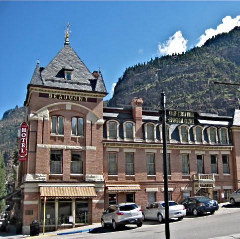
It's a beautiful little town full of Victorian architecture.  We parked the car and walked up and down the main street of town enjoying the sunshine and beautiful surroundings.  As we walked along, we took note of several possibilities for lunch.  Our plan was to get a quick look at the town, then drive on up Highway 550 toward Silverton, stopping back through for lunch.

Here are a few more photos of picturesque downtown Ouray:


Ouray has a year-round population of approximately 800, but thousands of visitors come each summer.


After drinking in the beauty of this town, we made our way back to the car to set off on the "Million Dollar Highway" section of U.S. Highway 550 between Ouray and Silverton.  It is part of the San Juan Skyway, considered one of the most scenic and spectacular mountain drives in North America.  


Roger and I agree!  To us it ranks right up there with the Pacific Coast Highway in its beauty.  


Love the Green!
Twisty Road - Glad we were in the car!

Red Mountain
Abandoned Mining Town
Check Out the Whimsical Painted-On Curtains!

Twisty 15 mph speed limit ok; easier to gawk!
Rusty Mountain Stream
Even the logs got rusty!

Roger had to put our poor little Matrix into third gear to get up many of the grades, and even had to use second gear a couple of times.

According to a roadside placard, U.S. Highway 550 in this area is the most avalanche-prone highway in the United States.  Evidence of this is this avalanche tunnel we drove through.

Soon we were back to Ouray, and saw the town from above, nestled in its little valley below.


As we walked along the street toward our lunch destination, we saw a tricked-out Jeep being raffled off by the town.  Ouray also has the reputation of being the "Jeep Capital of the World."  Ever since we rented the Jeep at Capital Reef N.P., Roger has lusted after one.  We decided to put our $5 into the raffle, "just in case."  The drawing is in October, so if we win, we'll be making a road trip from Mission, Texas to pick it up!

Our first pick for lunch had a "Closed on Tuesdays" sign on the door, so we walked a bit down the street and decided to eat on the roof of the Ouray Brewery.


What a treat it was to sit on the roof and watch the activity while we ate lunch and sipped a local brew!

It also gave us a birds-eye view of that part of town, so I snapped a few more photos from our seat on the roof.


Roger made the mistake of saying, "Look down there, Dianne, there's a kitchen store."  Well, that cost us a few bucks as we made a bee-line over there after lunch.  He should know better!

As we passed through the downstairs of the brewery on our way to Christopher's Culinaire, I snapped a photo of the swinging bar stools.  Those look like fun unless you've had too many beers!


What a wonderful day!  This ranks right up there as one of our full-timing favorites.  We know we'll be back to visit this beautiful town someday!

The pet photo of the day is one I took with my iPhone.  It shows Bandido and Tequila playing "It's Mine!" with a frisbee.  They really are best buds!!